Explore Britain with me...

Thank you for joining me. My journey has only just begun (September 2014). I will be travelling around the coast of Britain over the coming years. I hope to see all the coastline and much of the interior. I am going anticlockwise and randomly started at the Dyfi Estuary, one of the most beautiful parts of Wales that I already knew, overlooked by the most beautiful mountain Cadar Idris. I am looking forward to seeing and recording all sorts of things. My own passion extends to wildlife, geology, scenery, history, architecture and I am interested to meet people and see the communities and towns that I pass. I have read different accounts on the length of the coast and it varies enormously, but at its extreme could be as much as 37000km, taking into accurate measurements and including all the islands. I don't think that's feasible, but much probably is! I suspect Ill use a combination of foot power, bikes and busses if I am to do it all. Perhaps I can use boats too and maybe even swim a bit.

Sunday, 8 November 2015

Day 19 Dale peninsula

Sunday 1st November
Dale Peninsula
Walk distance 9km
Cycle 0km
Height 200m est
4 hours
1km walk to Westdale from Dale.

Total coastal distance walked 8 km
Total coastal distance cycled 0

Running coastal total distance 269.45km
Running height climbed 8311m

  Youth Hostel


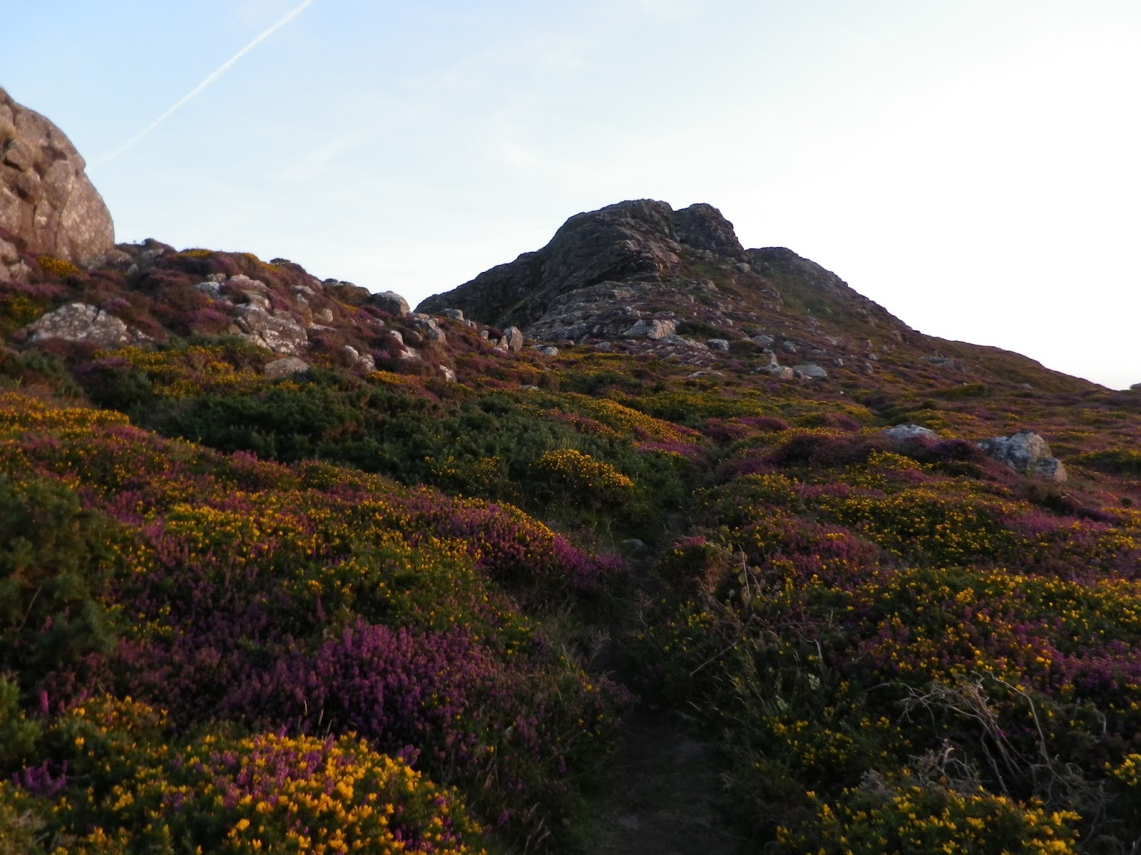
I parked in Dale at 8AM and walked back across the peninsula to Westdale, along a u shaped valley carved out by a glacier. Still early, the dawn light made the red rocks of the cliffs glow.  The walk towards the light house was pleasant and easy. Surprisingly for November 1st it was warm, the sky blue and the air still. I passed the broken rubble remains of World War two buildings and defences. These included a Navy meteorological and radar centre. 


The whole peninsula was militarised to protect Millford Haven. It is a shame so many buildings have been demolished.  As I walked I detected a strange noise in the distance. At first I thought it might be the noise of the wire on a distant flagpole.   But as I approached the point where the lighthouse was I realised the intermittent noise was a fog horn.  Aimed out to sea it wasn’t too loud on the cliffs.  After being silent for one minute, two bursts would warn passing ships.  There were ships on the move too and out to sea there was indeed fog.   I drank coffee on a high vantage point before carrying on to the lighthouses.  


There were two lighthouse, one a disused and now a private property, for sale at £975,000.  
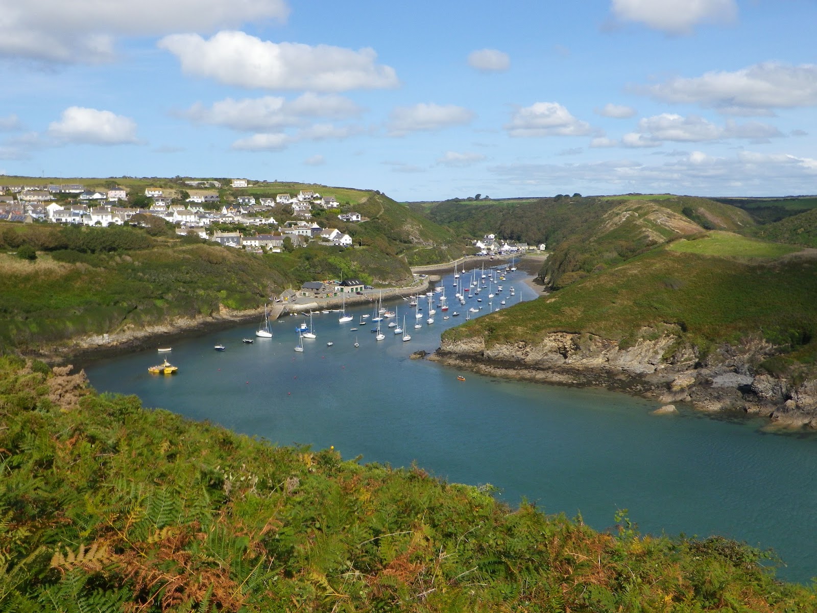
The other still working, adjacent to a row of empty admiralty houses.   St. Ann’s head was the scene of an accident when the tanker, Sea Empress, spilled 72000 tonnes of crude oil in 1996.  Rounding the point was rewarding and quickly lead to a very famous bay in English history.  
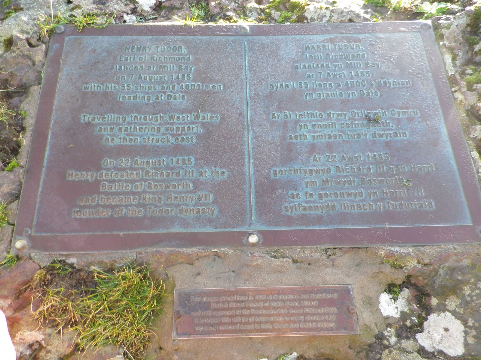
Mill Bay is where Henry Tudor and 2000 men landed in 1485.  From here he marched to Bosworth Field and defeated the Lancastrian king.  


Further on I reached West Blockhouse Fort, built to defend Milford Haven, and lovingly restored by the Landmark Trust.  Here I saw, and raced, my first oil tanker, racing to the fort to get a good photo.  All morning it had been getting warmer and I was keen to drop down to Watwick Bay to paddle and have lunch.  

 
With no wind the beach was incredibly warm.  With the tide going out the current felt too strong to risk swimming, but it was good to paddle.  After relaxing in the suns, and after an enjoyable lunch, the third three days running of oat cakes, cheese, apple, followed by coffee and chocolate I carried on. The path led up through scrub to another point where a huge tower, 50 meters high, at Watwick point guides modern shipping. As I passed it an Irish ferry went by. Only now did I start to pass other people walking in the opposite direction.  I saw my first birds of prey of the weekend, both a kestrel and buzzard.  


Today I saw even more flower out, including knapweed and daisies.  The walk then bypasses Dale Fort.  This is part of the Field studies council.  Many years ago I came on a field trip here, which I enjoyed thoroughly.  We spent much time studying the coastline and plants and animals living in the different habitats. I particularly remember looking at plants on sand dunes and identifying different types of barnacle.  In fact one of the lecturers was an inspiration to my later career in conservation. Thank you. The last part of the walk was through shady woodland along a tarmac road down to Dale and to the car park where I started. At my car, my temperature gauge read 19 degrees Celsius. Strangely on my return journey, via Brecon, the  weather transformed. At Brecon it was 10 degrees and thick fog.


Day 18 Little Haven to Dale


Saturday 31st October
Little Haven to Dale

Walk distance 25.4 km
Cycle 9 km from Dale to Little Haven, and 2km walk from Westdale bay to car at Pickleridge.
Height m 555 est
7.5 hours walking

Total coastal distance walked 23.4 km
Total coastal distance cycled 0

Running coastal total distance 261.45km
Running height climbed 8111m

I Started early again on Saturday.  A little annoyed I hadn't slept well, partly because of a guy arriving late in the dormitory.  I drove to a car park near to Dale for 8 and then cycled to Little Haven where I locked my bike up. The ride included a long climb and then went by a former RAF airfield.  Numerous derelict buildings could be seen on the site. Once again I noticed large flocks of starlings. There was then a very steep descent to Little Have. At 9 I started the walk. 


Unusually the start was not too steep and the walk to Borough Head quite different, passing through woodland and plantation.  There was a huge diversity of species including elm, pear, beech, sessile oak, sycamore, black thorn, pines and hawthorn. At one point I had to walk through a large number of flying wasps but these seemed so intent on feeding on ivy flowers they didn't bother me.  After a night of rain the path was very muddy and slippery. After the woodland the cliffs are more exposed. Gradually the ships at anchor came into better view. On Howney Stone, a small rocky islet, cormorants were sunning themselves.  In the shelter of banks there were a surprising number of plants in flower.  Today I saw even more butterflies, including red admirals and peacock. At St. Brides Haven the rocks became noticibly red. An attractive bay with cottages, church and an old lime kiln. 


Behind it, enclosed by an impressive wall lay St. Brides estate, a Victorian castle. The path then followed the buttressed perimeter wall. The cliffs gradually get higher towards Musselwick Bay. From here I am more familiar with the area as I have camped nearby and stayed at the former Marloes hostel. At Musselwick bay I swam many years ago and was given freshly barbecue mussels, by a guy on the beach, the first I had ever tasted. I was quite tired by now and had no idea of the time. I was looking for a suitable spot to stop, eat and sleep. Maybe I would shorten the walk. But the path was very narrow, and the grass dewey and I realised I had missed the turn off. Luckily a sign saying 2.5miles to Martins Haven reassured me. Just as I recognised the havens inlet and thinking I could sit in the sun on the beach I noticed a small group of people. They were watching a seal pub and its mother on the beach I was heading for.  The pup was almost as far up as the road. 


I took some photos and then walked up to the small look out station on the high point of the headland to have lunch. From here midland island Skomer and further away Skokholm were visible.  I had been walking for more or less for five hours. 
     

Reassured I had three hours before dusk, but not enough time to sleep I pressed on.  I had seen several seals swimming in the morning but closer to Martin Haven and around the deer park there seemed to be a pup on every stone beech. The next section of the walk is past Gateholm island and follows cliffs above Marloes beach. By now the sky was reddening. 

For the last two days I have seen so many choughs they seem common. One startled me considerably as I rounded a corner above Marloes. It flew up from the path feet away from me with a very loud caw. Then after a diversion onto the beach, I reached another disused World War II airfield, RAF Dale.  I followed one of the runways now partly covered in rubble. This must have been a very large site as there are lots of runways. Finally I approached the last bay with the sun setting.  A few surfers in the water, even though the light was fading.  From here I headed inland cutting off the peninsula, aiming for Dale.  Nearing the end I was tiring but enjoyed taking in the look of the colourful rendered houses, tall narrow square towered church and castle. The car was further away up the estuary than I realised but I made it just before dusk This was one of the longest walks I had done, pressured by the shortening day length.   I ate a lasagna at the hostel. This is the last night of their season and the place was much quieter than when I arrived.


Day 17 Newgale to Little Haven


Friday 30th October
Newgale to Little Haven


Walk distance 12.3km
Height 460m est
4 hours
Cycle 10km from Broad Haven to Newgale
Total coastal distance walked 12.3km
Total coastal distance cycled 0

Running coastal total distance 238.05km
Running height climbed 7556m


Arrived after a three and a quarter hour drive along the M4.  Soon after dusk I followed a sign into a carpark for the YHA and wondered where it was. The building was well hidden behind the car park.  I checked in and walked into Broad Haven. From the sea front I could see large white breakers and five ships illuminated at sea.  So refreshing to hear the sea. I ate a meal with a pint of Reverend James at the Galleon Inn.
After a good sleep, the only guest in a 7 bed dormitory I then cycled from the hostel to Newgale.   I followed the coastal lanes.  Where I could see the shore large waves crashed against the cliffs, as it was high tide. The first few minutes of cycling were hard, having to climb a very steep hill to Haroldston West at 91 meters. Laden with walking boots and all my walking gear I walked the steepest bit. There were two more similar hills to climb. But the down hills made up for it and some was on the level. Closer to Nolton haven I passed large flocks of starlings feeding on insects in the fields or perched on wires. Over 500 on one count. At Newgale I had Welsh cakes and coffee in Pebbles cafe and then cycled back to my start point parking my bike up at Newgale sand car park. 

Unlike the last time I was here, the seasonal RNLI lifeguard hut and volunteers had gone. While getting changed a friendly council worker, emptying litter bins, explained the main season was over but that he was back on duty for half term. He started early so he could get home to watch a match. There were several vehicles in the car park and a number of people were changing into wet suits. The wide sands were invisible under the high tide. As I started walking along the pebble bank I watched some surfers paddling out and waiting patiently for the right waves. The waves were pretty big. Whilst I watched I did see one ride a wave briefly.  


The path briefly followed the road and then started to climb the cliffs. 
Very soon a large chimney became visible.  This is all that remains of Trefane cliff colliery. Looking harder there are also remains of machinery and spoil heaps.   The site closed down in 1905. 

The cliffs along this section are very crumbly. Rickets head, perhaps of harder rock stands out. In the warm autumn sunshine I saw a butterfly and passed a couple watching a large toad hide itself in the heather. The light was wonderful. Surprisingly a number of flowers were still out, the occasional head of knapweed, ragwort and thrift.  A group of choughs kept calling as well. Rounding a corner Nolton Haven appeared. Several people were bobbing about in wetsuits. I stopped for a morning break sitting on a rock on the beach. The beech was busy with a few families and surfers. But dogs and dog walkers predominantly.  The owners identifiable because of their little black bags of poo.  Others identifiable by the high pitched shouting as they try to retrieve their dog from playing or fighting with another.  I counted ten dogs on the tiny beech. You’ll realise I am not a pet dog person, although I love working dogs. In my childhood I spent much time curled up next to warm and often wet gun dogs. This haven was another important place for exporting coal from. Hard to imagine these, now tranquil, places being so busy.
Moving on there is large scale land slips and hollows leading up to Druidston. The views out to sea showed large even waves rolling in, but countering this from the south the wind blew smaller waves at right angles. Large ships sat at anchor, the same ones I had seen in the dark. I had lunch at Druidston Haven beach. It was warm enough for one man to be shirtless. I did not think it quite that warm. I spent some time looking at rock pools and watched a top shell slowly moving, creating a path in the sands. 


Disappointingly, after lunch, the wind picked up and it clouded over. Just before Broad Haven I glimpsed the towers of Milford Haven. They looked surprisingly close.
Broad Haven is a small place, but it boasts a shop, pub, bar and cafes. I walked on the sands as the tide was now out to the pretty village of Little Haven. Here, on the beach, I saw my first oystercatcher of the day. The cliffs here have amazing folds and there is one very large arched roof cave. I found a RNLI shop and thought I should support them after hearing one of their lifeguards was rescued by helicopter after he attempted to help someone stranded on the cliffs. I had seen and heard the helicopter the evening before.   The lady in the shop was very kind and talked about the walks near Dale. The short walk back to Broad Haven over the cliffs passed a sign to Little Haven, it read Little Haven big sign.
At Broad Haven I had a coffee and bumped into a chap with his family that I saw near Newgale photographing the bay. 
This weekend I tried Nordic walking again. I realise the poles I have are normal trekking pole, but they seem to make walking easier. It is a dilemma what to carry on these walks. Today I did not use my binoculars and carried an extra litre of water undrunk.  If I do not take these tomorrow I can guarantee ill need them.

I then drove to pick up the bike and returned to the hostel to shower and cook a meal. Whilst cooking I chatted to a couple who also walked in the area. They were disappointed to hear Marloes hostel was now shut. Sad the small self-catering hostels seem to close. It was much nicer the Broad Haven one. They kindly left me lots of chocolate nibbles.  

Monday, 14 September 2015

Day 16 Solva to Newgale

Day 16
Sunday 6th September

Solva to Newgale

Walk distance 7km
Cycle 0km
Height 220m est
2.5 hours
Bus back to Solva

Total coastal distance walked 7km
Total coastal distance cycled 0

Running coastal total distance 225.75km
Running height climbed 7096m


To walk to Newgale meant I had to start early if I was to catch the bus back mid morning.  Whilst the early start was an effort the walk was rewarded by seeing no one except a dog walker by Solva and a group of people at the very end point.  I started out from Upper Solva at 8a.m. The first bay was magnificent with a stream flowing through a reed bed and into a pebble beach.   The cliffs along this section are sedimentary rock.  Dinas Fach and Dinas Fawr are too long ridges of harder rock that protrude into the bay. The coastal path skips these and I didn’t have to time to walk onto them.  


Soon after starting the call of a peregrine alerted me and then I saw one sat on a smaller cliff ridge.  After sometime I realised a second was perched further along.   Content with seeing them, I walked up the path to a point where I was so close to one, and yet it didn’t fly off. With my binoculars I could see the detail of their markings, including how the wind was moving their breast feathers.    


Further on I took some pictures of cows and choughs. A group of 11 choughs.  As a rare bird they seem to be thriving here.  Nearing the end I halted suddenly when I saw a slowworm on the path.  Basking, I was able to take several photos before it moved off into the heather.  


Hemlock agrimony
Orpine
Goldenrod


This was a good time of year to walk as all the path is colourful wit heathers and other plants. Finally I dropped down to Whitesands and walked along the beach to the lifeguard hut to find out where to catch the bus.  I noticed the traffic noise, but it was only when I was on the road I realised there was an old car rally.  During the twenty minutes or so I was waiting on the bus at least 1000 cars passed me.


The bus dropped me off in Upper Solva and I picked up my car then returned to Newgale, parking by a café where I took coffee. I spoke to lifeguards about swimming.  With the sun out it seemed possible.  The air temperature and sea temperature were both 14 degrees, much colder than the 21 to 23 degrees I prefer in the Droitwich lido – and even then I rarely go in if the air temperature is below 18.   No one else was in the water.  I rolled up my trousers and took my shoes off and paced up and down in ankle numbing water.  Then I went back to the pebble shore, changed and went in quickly! It was so cold. I swam briefly but when my head was under the water it took my breath away. I was out pretty quick! At least, for the first time this year I had been in the sea.

After the swim and change I headed home, this time taking the more leisurely attractive route via Brecon.  Within thirty miles of Pembrokeshire the temperature was up to 21 degrees and it was blue sky all the time. Where had this weather been all weekend? Also I had achieved the 225 km mark and climbed over 7000meter in just 16 days! Leaving Cardigan bay felt like I really I am making progress in my journey around Britain. I have even moved off the north Pembrokeshire map and am now onto the south Pembrokeshire map.  More important than the distance is the new places I have seen, amazing scenery, the wildlife and really nice people I have met. I have also learned a lot about the history of this part of Wales. 

Day 15 St.Justinian to Solva


Saturday 5th September
St. Justinian to Solva

Walk distance 16.8km
Cycle 0km
Height 553m est
6 hours
8km cycle to St Davids and back

Total coastal distance walked 16.8km
Total coastal distance cycled 0

Running coastal total distance 218.75km
Running height climbed  6876m


Once again I cycled to St David's.  This time Gianni’s ice cream parlour was only just open and their coffee was not ready.   The barista wasn’t happy to give me a poor coffee so I had to leave to wait for my bus.  As I got onto the bus he ran over and presented me with a free coffee to take with me.  I thoroughly recommend Gianni’s! The bus took me to St Justinians’ to where the new lifeboat station was being built.  Even on a Saturday builders were at work using a massive crane to move blocks.  Soon after starting I met a long haired man with binoculars who told me a little of what to expect and where to look for dolphins.  With a strong north wind, as well as a current, the water in the sound between the mainland and Ramsey was flowing so fast, with an enormous swell.  On the far side canoeists looked like they were being tossed around the Bitches. 

This is a series of very jagged rocks by Ramsey island.   Ramsey island is owned by the RSPB.  If it was the spring I would love to visit to see the nesting birds. On the headland a ruined Quakers house was evident. Apparently Quakers forced off their own land settled here, on the margins of Wales, before they left eventually for America.  Shortly after passing the ruins I had wonderful views of a seal close up.  The chap I had met said to follow the diving gannets to find dolphins. This I did ,and sure enough had a brief glimpse of one! Rounding the corner of the headland it was much more sheltered. 


Now I could see St Brides bay as well as other islands further south.  The walk was easy to start with.  At Porthclais, the natural harbour to St. David’s I suddenly came across many people.  There were many dozens of canoeists, walkers and climbers in groups. The next section all the way to Solva was up and down and also busy. This was the first part of the walk where I felt I had lost the feeling of remoteness since Aberwystwth. 

Luckily I found a nice sheltered bay and the sun finally came out.


 Today I experimented Nordic walking with my poles. I had once been on a training session to learn this technique and it took a while to remember how to do it.  The problem was finding a rhythm to match my foot pacing.   Once I remembered It was as simple as counting or marching one two, one two it was easy.  I didn’t quite resolve how to use the poles on the narrowest paths where they got caught in the heather.  I think they helped and I will use them again.  Dropping down along path to Solva I was struck by the revolting smell of decaying dog poo.  In the sheltered bay, with the full sun it smelled terrible.  It seemed strange that such a pretty village was spoilt and that presumably locals and visitors allowed dogs to crap on the paths leading and to and from the place. 

By the time I reached Solva I was tired and decided that I would stop at this point.  I had a very rank coffee on a terrace of a boat club.  Realising a bus was about to leave I gladly abandoned my coffee and raced to catch the bus. 

Unexpectedly I was back in St. David’s early so decided to walk around.  I walked around the outside of the cathedral and Bishops palace and wandered past the few shops. Without money I didn’t venture inside.   Many years ago I had visited the site.  St. David’s is the birthplace of St. David’s, a sixth century Christian missionary who influenced many people.  Over 100 churches and monasteries are dedicated to him and pilgrims travelled to Pembrokeshire to his home and to places he frequented such as Whitesands bay.   A chapel in St. Non’s bay, which I walked past, by Porthclais, marks his birth place.  Today tourists flock to the cathedral city, and it is very much a honey pot.   On the return I cycled back down to Whitesands bay to enjoy an ice cream on the beach.   Back at the hostel eating was easy as I reheated my chilli from the evening before.  


Making the most of the daylight I decided to walk up the rocky hill, Carn Llidi Brychan, behind the hostel to see the sun set. I am glad I did as the light on the heather clad hill was amazing. The views back across the St. David’s peninsula and across Ramsey island were great. Finally I settled down in the hostel to chat again.