Saturday 27th February
Cycle 0 km
Height 690 est
6 hours
Total coastal distance walked 20km
Total coastal distance cycled 0km
Running coastal total distance 343.65km
Running height climbed 11286m
Saturday
Caught the shuttle from outside Pembroke coop. A rather lengthy journey to get to Stack rock, but made all the more interesting by chatting to the bus driver. Detecting the home ascent he was from Bracknell. He had moved down to Pembroke 12 years ago to enjoy the beautiful coast, cheap living and traffic free driving (except in the summer).
Caught the shuttle from outside Pembroke coop. A rather lengthy journey to get to Stack rock, but made all the more interesting by chatting to the bus driver. Detecting the home ascent he was from Bracknell. He had moved down to Pembroke 12 years ago to enjoy the beautiful coast, cheap living and traffic free driving (except in the summer).
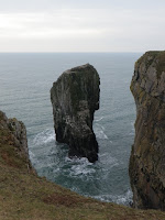
Started walking from stack rock date admiring
the huge natural arch. The walking was easy and on the level. On one side the
Rocky almost limestone pavement gave way to cliffs and on the other the
military training area. Several tanks were dotted around, with their camouflage
it was easy to miss them. The path followed a well Defined track, occasionally
close to the cliffs, caves, sink holes and steep gullies were passed. This
track is normally shut in the week. Once leaving the military area the chapel
of St. Govan is reached. This thirteenth century building tucked into the
cliffs, overlooks a stack and natural arch.
 The next section of walk is defined
by a steep valley lined with WII defences. Because of the numerous car parks I
saw many walkers and dog walkers. None more so than in the lead up to
Broadhaven below Bosherton. So many dads carrying children in rucsacs! This is
one of my favourite places having camped at Broadhaven in the past. I have fond
memories of swimming here, sheltering from the sun in a cave and watching first
pike and then a family of otters from the long bridge over the lily ponds. Too
many people for the latter today. I briefly stopped for a bite to eat in the
cliff top dunes above the Sandy bay. From here I continued along the limestone
cliffs admiring a huge swallow hole. Barafundle beach is stunning. A few choughs
kept me company.
Overall I saw very little wildlife all day. The path drops
down to Stackpole where the geology changed dramatically in a fault line to
sandstone. Here I had a coffee in the National Trust boathouse cafe. After
having been chilly i was now overheating and was glad to be out in the fresh
air. I wasnt sure how I would do times use for catching a bus back, do I
decided to walk onto freshwater east. Rather than walk up to the main road for
a big bus or wait three hours I decided to press into Manorbier. The dunes at
freshwater were impressive piled up onto the cliffs. The sandstone cliffs are
full of undulating folds. I stopped at the last Sandy bay to eat some malt loaf
and realised I had less than an hour to walk to Manorbier and catch the bus.
Despite the steep inclines and long distance I marched fast. I was relieved to
see the castle and walked quickly up through the village to the bus stop. I had
fifteen minutes spare. The bus was perfectly on time.


No comments:
Post a Comment