Explore Britain with me...

Thank you for joining me. My journey has only just begun (September 2014). I will be travelling around the coast of Britain over the coming years. I hope to see all the coastline and much of the interior. I am going anticlockwise and randomly started at the Dyfi Estuary, one of the most beautiful parts of Wales that I already knew, overlooked by the most beautiful mountain Cadar Idris. I am looking forward to seeing and recording all sorts of things. My own passion extends to wildlife, geology, scenery, history, architecture and I am interested to meet people and see the communities and towns that I pass. I have read different accounts on the length of the coast and it varies enormously, but at its extreme could be as much as 37000km, taking into accurate measurements and including all the islands. I don't think that's feasible, but much probably is! I suspect Ill use a combination of foot power, bikes and busses if I am to do it all. Perhaps I can use boats too and maybe even swim a bit.

Friday, 12 June 2015

Day 12 Fishguard to Pwll Deri


Day 12
Sunday 31st May
Fishguard to Pwll Deri

Walk distance 15km  est
Cycle 0km
Height 460 m est
6 hours
Bus from Pwll Deri to Goodwick Harbour

Total coastal distance walked  15km
Total coastal distance cycled 0

Running coastal total distance  168.45km

Running height climbed  5273m


Walked the mile down the lane to the bus stop. The lanes are mostly lined with stone walls bedecked in plants. This one had an array of coastal and wayside plants. I counted over 30 species in flower and there were others not yet mature enough. I even saw orpine, a pretty rare plant (sedum telephium), but one that wasnt in flower yet. While I waited for the bus I took photos of some of the flowers. The bus arrived, leaving early and dropped me off at the rail station at Goodwick. The route went by the headland giving me a tantalising glimpse of the walk.  I was tempted by a cafĂ© at Goodwick and enjoyed a coffee before starting. 

Goodwick is sheltered and a huge Agave was growing in a front garden. 


As usual the first part involved a climb, past houses above the port and finally onto the open cliffs. A metal beacon sponsored by British gas and a canon marked this point. Looking back to the harbour I could see several ruined buildings, probably WW2 fortifications. On one was a most surreal and out of place graffiti picture of a head. 


Rounding the first point I watched a ferry approach. The weather was amazing and it was good to see so many flowers. The purple foxgloves were the most striking plant. In places there were swathes of pink thrift or red campion, bluebells or  blue of  spring squill and white of sea campion; occasionally palettes of each colour mixed. In places entire walls were carpeted. It was not long until I saw my first seal from a low cliff top. This one was definitely watching me. I sat down on a grassy bank for elevenses to watch him and every few minutes the seal would reappear. When I walked on the seal followed me around several coves. I also had lovely close views of meadow pipits and stonechats. 


Cwm Felin was s sheltered green oasis. Mostly dominated by sycamore. On the next point was the stone commemorative inscription to the French invasion in 1797. 

With the warm sun I noticed lots of insects and took some photos of a few. I was really struck by the roses growing amongst the heather. In one rose flower I watched a small spider. A tiny beetle walked by it, maybe after eating some pollen. The spider pounced on it but immediately withdrew. Perhaps it could not bite through its shell. Butterflies included wall and common blue.  


So good to see calves out in the fresh air eating real food. At Pwlluog there is a small beech where I saw more seals. Sheltered from the breeze I ate lunch watching one seal who kept checking on me. He seemed to hang in the water. I was even able to sunbathe. Rounding Strumble head the wind was fierce and seemed odd to see a fishermen perched on an exposed headland rock, by crashing waves. The lighthouse is impressive but unfortunately inaccessible. A sign in the bird hide explained its purpose and design. The light house is actually on an island. Islands and stacks are a real feature of this part of the coast. 


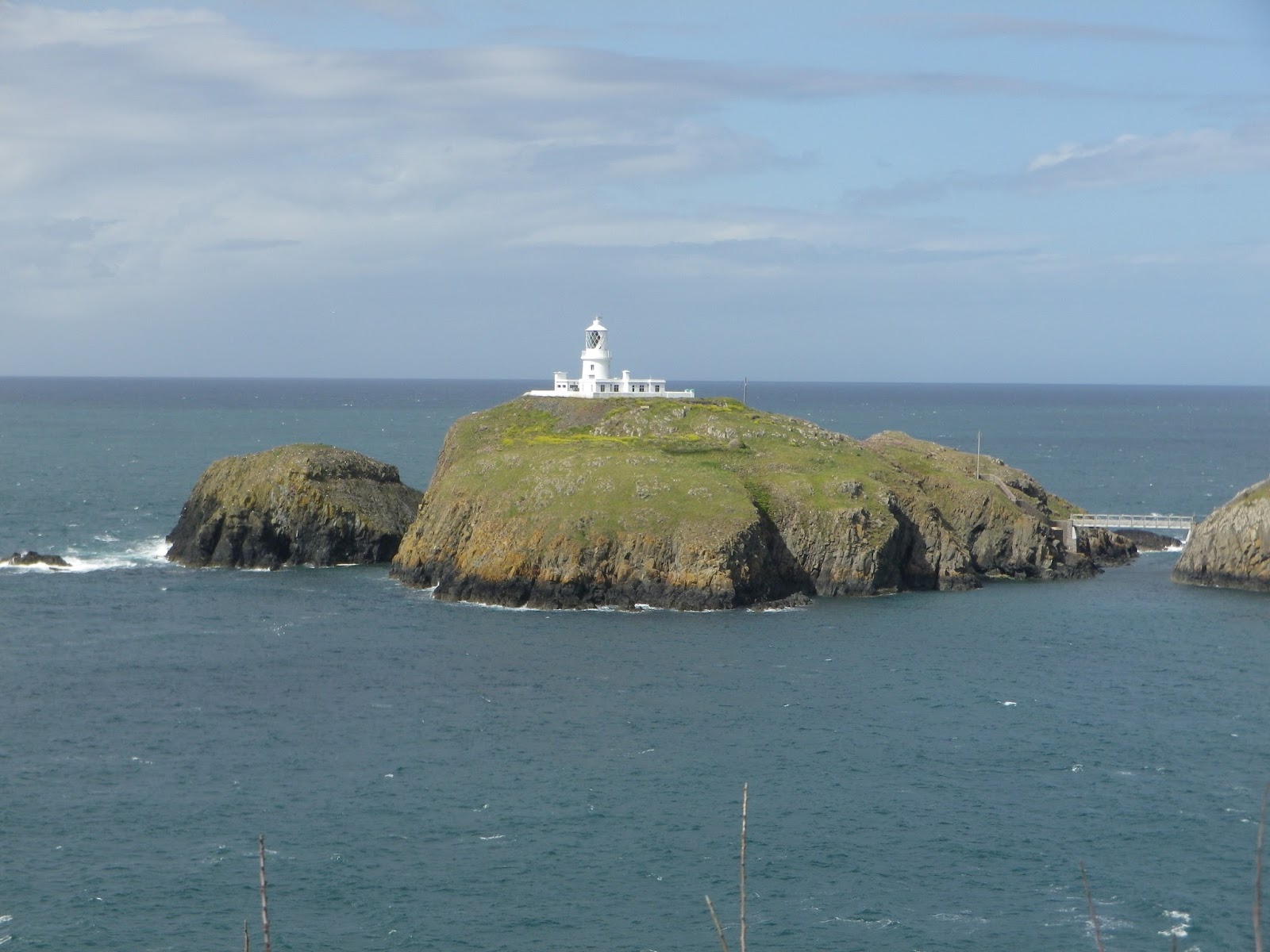
The higher vegetated ones are alive with seabirds, at present mostly gulls but also guillemot and razorbills. The last section to Pwll Deri is truely spectacular. Exposed to the full force of the wind, the several hundred foot high jagged cliffs are beautiful. Still more carpets of flowers. Also good views of choughs again.

Finally reached the hostel after a longer time walking than I had realised.
The evening in the hostel was very pleasant.  After a pasta sausage meal and a relaxing sit down I chatted to other hostellers.  These were all from abroad, from Germany and Netherlands.  One guy was a forester and another a land agent. The German lady worked with refugees and the Dutch woman with children.   We chad a lot in common and chatted all evening.  Before it was dark I walked up to the high point behind the hostel, Garn Fawr.  This is also a hill fort.  Every hill and promontory has an ancient fort on it here.  For instance, the nearest promontory of hard volcanic rock, Dinas Mawr has several ditches and banks to protect it.  Beyond this point are several islands and large rocks.  The view from Garn Fawr, with the sun setting were fantastic.  Numerous green fields make up a patchwork covering of the land right up to the cliff edge. Then along the cliff is  a very narrow swathe of more natural land.   Wildlife in this country is really pushed to its limits.  Due to the forecast the serious solo coastal walkers were all keen to walk the path the next day before the gales hit. One guy said he would rise at 5AM. Far too early, and I hoped he didn’t wake me!


Preseli Hills

Saturday 30th May
Preseli Hills

Walk distance 8km
Time 4 hours.


I left home early in the morning with the hope of making the best of the good weather. I travelled along the scarp side of the Brecon Beacons. A beautiful journey and really quiet until I reached Caenarfon, where there was traffic. Thankfully the cars and caravans were all going in the opposite direction, as it was the end of half term. With barely a stop I arrived four hours later, at a small car park, on the flank the Preseli hills near Crymych. I have never been to these hills and they dominated the previous days coastal walking, so I was keen to explore them.  Within 50 yards I was struck by the range of ferns clinging to the stone walls along the first track way.   As I entered the open access moorland I heard the delightful call of a cuckoo. I walked steeply up to the twin forts of Foeldrygarn.
 Gr. 157337.  The forts were completely tumbled down, but it was possible to gauge the size. The location was well chosen overlooking a vast area.

From the top I had my first glimpse of Cardigan bay. From the fort I then cut across the ground to the south west towards Carn Ferched. On a low plateau the ground became wet and spongy with sphagnum. The tell tale signs of cotton grass and cross leaved heath suggested the chance to see carnivorous plants.
I quickly found colonies of round leaved sundew, there sticky leaves glistening in the sun. Carn Ferched was small and unimpressive, not even waist high. However walking up to it my body shivered. This was something special. I held onto it and walked around it three times in the hope it would bring me luck. As I walked away two cuckoos calling from the wood flew past. One chasing the other. Then one perched on the cairn. So my luck was in.

I then continued west along the ridge, not as far as the high point, but to Carn Bica. The landscape became rocky with bizarrely balanced rocks and steeply angled crags. Carn Menyn is supposedly the source of the Stonehenge rocks. On the return I walked around each crag. I couldn't see any sign of quarrying. Many of the rocks are split into building block shapes but all looked natural. Id noticed the cries of young children in the distance and was surprised when a small boy appeared at my side asking if I knew where Beddarthur stone was. When his parents, brother and tiny dog caught up I tried to read the landscape and map to work out where it was. The mother wanted to go off in a different direction. I encouraged them to follow me, and after a mile found a small ring of standing stones. The stones were about a foot high, but like Carn Ferched there was something about the place that made this feel special. On Carn Bica I sheltered from the wind and enjoyed my lunch listening to the near constant calls of cuckoo, skylark and meadow pipit. The views are amazing.


 I could see Caenarfon bay on one side and Cardigan bay on the other. For the first time I saw the towers of Milford Haven. I can see why this place had some religious meaning. The rock formations reminded me of Dartmoor although these seem more dramatic. In them I could see figures and animals. A solitary man walked past and not seeing me seemed to do as many others probably do. He stood for a while in the centre of the circle, probably contemplating the history of the place.


Back to Carn Menyn I watched a wren appear and then disappear into a crevasse. It makes sense that their latin name is Troglodytes troglodytes.  

The walk was really enjoyable and after I then continued on to Fishguard to pick up supplies for the Youth Hostel at Pwll Deri. En - route I stopped at a quarry which may be the true source of Stonehenge. This was much closer to the coast and even today is worked. This was near the village of Crosswell at approximately GR 116362.
This was my first trip to the Peseli hills and I thoroughly enjoyed every minute of the walk.

Friday, 8 May 2015

Ancient barrows and forests.

Tuesday 28th April
Ancient barrow and Forests

Tired after two days walking I chose to visit local sights,as well as return to the lovely garden centre at Moylegrove.


Pentri Ifan
This is the largest ‘Dolmen’ and is 3500BC old.  Only a few stones remain of the once 30 meter long structure, a tomb for the dead.  It overlooks the nearby mountains as well as the coast and Dinas Island.  The stones that remain were the main entrance and include a huge 5 meter long capstone supported by 3 stones.


A very atmospheric place with very good views of the surrounding country.

Pengelli Forest
A Wildlife Trust reserve, part of the largest oak woodland in West Wales.  Part is 100 year old oak growth after felling in WWI. Here plants like bilberry and common cow wheat grow. Else where there is more variety and under story of hazel.   Pengelli Forest is well worth a visit.


Day 11 Newport to Fishguard

Day 11
Monday 27th April
Newport to Fishguard

Walk distance 19km
Cycle 0km
Height 800m
6 hours
Bus from Fishguard to Newport

Total coastal distance walked  19
Total coastal distance cycled 0

Running coastal total distance  153.45km
Running height climbed  4813m


I took the bus to Newport soon after 9am. There was a small market in the road leading to the private castle, selling produce like local honey. Tempting to buy but not to carry it. The walk started well climbing up smaller cliffs than the day before. The path dropped down to several beautiful and fairly sheltered beaches. The air temperature was apparently only 5 or 6 degrees and in the wind under clouds it felt bitter. In contrast there were moments when the sun shone and it was hot. A lizard scuttled across the path at one point so in the sheltered places it must have been much warmer. Leading up to Cym yr Eglwys I walked under a tunnel of blackthorn.


With rain threatening the wind blew the petals down like snow. The ruined church on the shore was the result of a powerful storm. Although the shortcut was tempting I started the climb up to the headland of Dinas island. I was rewarded by my first proper views of razorbills and guillemots perched on a stack. All in strong plumage they looked beautiful. Some of the razorbills were on the sea and occasionally went under water after food. Some of the birds were sat on eggs. The rain held off and I was able to sit on the headland, Pen y Fan, at 142 m in sunshine. After a bit of lunch for the first time since walking the coast my ankles ached. The next section of cliffs also included beaches. In places trees on the cliff path were growing horizontally. Towards the end in a more sheltered spot I saw spring squill.  

At a rather smart caravan park I met one of the coastal path rangers. He asked after my walk. He was discussing improving the path on the cliff side with the owner. There was a magnificent rock arch beyond the park.


The path crossed the flanks of heather clad moorland. Unusually wood anemone carpeted underneath. As the harbour became visible wildlife still abounded as I watched two gannets diving.


Birdlife had been abundant all day. Rather than list everything the birds that were most obvious were chiffchaff willow wabler and whitethroat. All around signs of spring. I love the reptilian scaled fronds of ferns as they emerge.


On the last promontory overlooking Fishguard lower town is the remains of a fort complete with canon.


Once in Fishguard I just had time, before 5 pm to call in to the town hall to see the famous tapestry commemorating the 200 years since the last invasion. Strange to think of this happening only 200 years ago. In 1797 the French launched an invasion, landing just south of Fishguard. They had hoped the poor would join them to overthrow the crown.  They succeeded in landing and even set up a camp, and pillaged the surrounding area. Thanks to the quick reactions of the military and locals they realised they could not succeed and surrendered fairly quickly.  A number of people were killed and building ransacked. We are so lucky that besides the bombings in the wars that theirs been peace here for so long.


In the evening I walked to the Globe to try their curry.   The pub was busier and a young man called Sam joined me at my table.  He was from London, and was a photographer down to film a lighthouse for an advertising campaign for EE.  Made for an interesting evening sat in front of the hot wood burning stove.


Whimberel near Newport


Seaview hotel


Day 10 Moylegrove to Newport

Day 10
Sunday 26th April
Moylegrove to Newport

Walk distance 15.2km
Cycle 0km
Height 880m est
5 1/2  hours
Cycle from Newport to Molygrove

Total coastal distance walked  15.2
Total coastal distance cycled 0

Running coastal total distance  134.45km
Running height climbed  4013m


Drove to Newport and parked on the Parog and then rode my bike to Moylegrove. I had hoped to avoid the steepest hills and highest point, but with one wrong turn at Navern I encountered both steep hills and the high point. But the village of Navern was very picturesque and I wouldn't have passed its castle if I had gone the planned route. I had just been pushing my bike up some steep turns and was pondering whether cycling was worth it when I passed a near hidden sign behind a gateway. I love the way so many places are understated.


The castle has very little stone left but the layout is clear to see with gateways, motte, moat and a second tower platform. Best of all were the spring plants. Just inside the gateway three early purple orchids were in bloom, along with masses of primroses and  wild garlic coming up. Back onto the lane I cycled to Moylegrove. The lanes are very quiet and I only saw one car. Once I locked my bike, put on my boots and loaded my rucsac I set off following the small lane to Ceibwr Bay.


The first stretch of walk is impressive. First of all a rock stack and then the witches cauldron. This is a sea pool surrounded cliffs and linked with an arch. More like the blue lagoon. Unfortunately the sun light was so bright my photos didn’t work.  Lots of cliff flowers were just starting to come out.
Photo shows a badger sett workings blocking the path.


Bluebells, sea campion, violet, daisies, thrift, with the white sea scurvy carpeting many areas. Gradually the cliffs rose higher and higher. In places where the cliff had collapsed heather grew on the tumbled rock and scree. Elsewhere bracken and grass tied the soil. Much of the cliff looked grazed and cared for. Choughs kept me company for much of the walk indicating healthy grassland full of insects. Once again I wondered about the illusive dolphins. The higher I went the more exposed and the colder it was. The wind was strong but was from the sea. At one point my cap took off and blew into a field. I had to climb a barbed wire fence to rescue it.


Glancing to the sea I saw something disappear. Watching again an animal surfaced and went under again. I knew it was not a seal and hoped it might be a porpoise or dolphin. The kayaks appeared and I wondered if they would drive it off. A bit further on after the kayaks had gone ahead I realised the noise of it breaking out of the rough water drew my attention again. I watched as every few seconds it breached. Sometimes I could see its fin, most of its body, its beak and even the color contrast. I tried to get a photo but it was so quick. It was a dolphin! (I think).

Although lower I was still over 300 feet above it and it looked so small. Several times I stopped to watch it further along. The wind was so strong and cold my eyes watered. Soon after as the cliffs dropped away I disturbed a male peregrine. He flew off and all the nearby oystercatchers flew off in alarm circling until the peregrine returned to his perch. They then separated and went back to there business. Finally dropped down to a beautiful sandy beech it was so nice to walk on the level and hear the waves close too. I rounded the sand dune. In fact the sand dune and back drop of crags looked more like the Sahara. The estuary beyond with the Parog opposite and village above was pretty. I did not think it possible to walk up the side of river so cut back through the dunes and was glad to see a cafe. The lady was about to close but served me a coffee. She quizzed me about the walk. Her son had run in the marathon today and done very well. The last bit of walking was further than I realised up the estuary to a bridge and back down to the Parog. It was rewarded by close views of shelduck feeding and in areas of shaded path by colours and scents of blackthorn, and Alexanders, wild garlic and even emerging cow parsley. (and the wreck of a boat)


In the evening I ate a rather good steak and beer in the Hotel restaurant and retired early, exhausted.